Steer on Stratigraphy, Segment by Segment
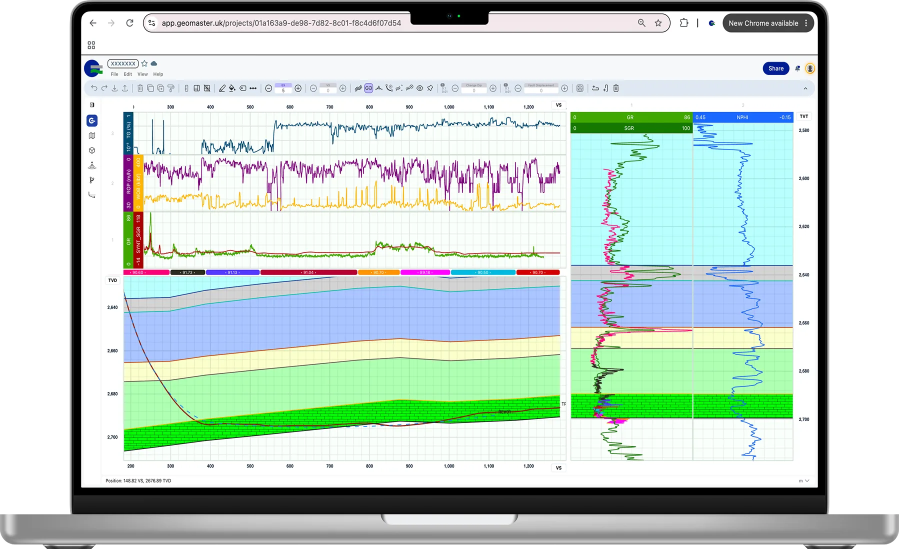
GeoMatch correlates the lateral's gamma ray against a type well and shows where the well sits in the formation. Set the dip of each segment, add faults where the log jumps, and keep every interpretation as a version.
Included in every plan, including Free.
Watch
Drag It. Watch It Match. GeoMatch in 50 Seconds
Your gamma ray against the model log from a type well, with no structural model required. Cut the lateral into intervals, drag them until they lock, and see the section, model log and TVT recalculate instantly in your browser. Then ask GeoEngine to check it.
The video uses sample data. Subtitles are in the player menu.
How It Works
From Type Well to Position in the Target
Six steps, from an empty project to an interpretation you can steer on.
Create a GeoMatch
Pick the geosteering well, its trajectory and the log to steer on, usually gamma ray. Then pick the reference well (the type well), its trajectory and log, and the starting point on the plots, usually the kick-off point.
Layers From the Type Well
The formation tops of the type well become layers on the cross-section. Tick one top as the Sweet Spot and it becomes your target zone, running to the next top below.
Segments Along the Lateral
Split the lateral into segments and set the dip of each one. The layers bend with your interpretation, and the type well log is redrawn along the well as a synthetic log.
Match the Logs
Adjust each segment until the synthetic log lies on the measured log. When they match, the cross-section shows where the well really sits in the formation.
Faults Where You Need Them
Cut a segment and give it a fault displacement when the log jumps. Thickness change handles layers that thin or thicken along the lateral.
Save a Version
Save the interpretation as a version with a note. Versions are permanent, so you can always see what you believed at any depth, and why.
On the Screen
One View: Logs, Section and Type Well
Everything you need to make the call, side by side and in step as you edit.
Log Tracks
The lateral's logs against vertical section: gamma ray with the synthetic log over it, plus any other curves you load, such as ROP or gas.
TVD Cross-Section
The well path through the formation layers in true vertical depth, with the Sweet Spot shaded and survey points on the path.
Segment Bar
Each segment's dip shown above the section, colour-coded, so you see the whole interpretation at a glance.
Type Well Tracks
The type well's logs in true vertical thickness, with its tops, and the lateral's log laid alongside to compare.
Tools
Built for the Way Geologists Correlate
The tools on the GeoMatch toolbar.
Change Dip
Set the dip of a segment by typing it in.
Fault Displacement
Give a segment cut a throw, up or down, where the log jumps across a fault.
Thickness Change
Let layers thin or thicken along the lateral instead of forcing a constant thickness.
Depth Shift
Shift the whole interpretation in depth when the type well and the lateral are on different datums.
VS Azimuth
Choose the vertical section azimuth the section is drawn on.
Exaggeration, Scale and Ruler
Vertical exaggeration, linear or log scale on each track, grid lines, and a ruler for measuring on the plot.
Fills and Patterns
Solid colours, gradients and lithology patterns for each layer, with conditional formatting.
Undo, Copy and Reset
Undo and redo, copy and paste segments, and reset a segment to start again.
GeoEngine
A Second Opinion on Every Segment
GeoEngine, the AI assistant in each project, reads your GeoMatch. It checks your interpretation and suggests changes, and you decide what to keep.
- ✓Says where the last survey point sits in the Sweet Spot, in metres from its top and base
- ✓Scores each segment of your GeoMatch against the type well, and with Score this segment says what it would change
- ✓Prepares a new GeoMatch and opens the form prefilled, with the kick-off point as the starting point, for you to confirm
- ✓Offers to save a version after a significant edit, and compares versions on request
Every Interpretation Kept
Save a version whenever the picture changes. Nobody can delete a version, so the history of the well is always there for the post-well review.
Version history →One Picture for the Team
Share the project and the client, the operations geologist and the directional driller all open the same GeoMatch, with viewers following read-only.
Project sharing →GeoMatch FAQ
What geosteerers ask before they load their first well.
Correlate Your Next Lateral in GeoMatch
Free to start, with one project of your own. No credit card required.